I haven’t tried google maps go. It looks like a similar idea to GMaps WV. I was surprised it didn’t have any trackers.
On OSMAnd, you have the feature to mesure the distance between two points FYI but not the area nor the elevation for more than 2 points
Just FYI : Waze is a Google app bought some years ago (https://fr.m.wikipedia.org/wiki/Waze). So even without trackers, it’s not an option for me on degoogled world (my point of view)
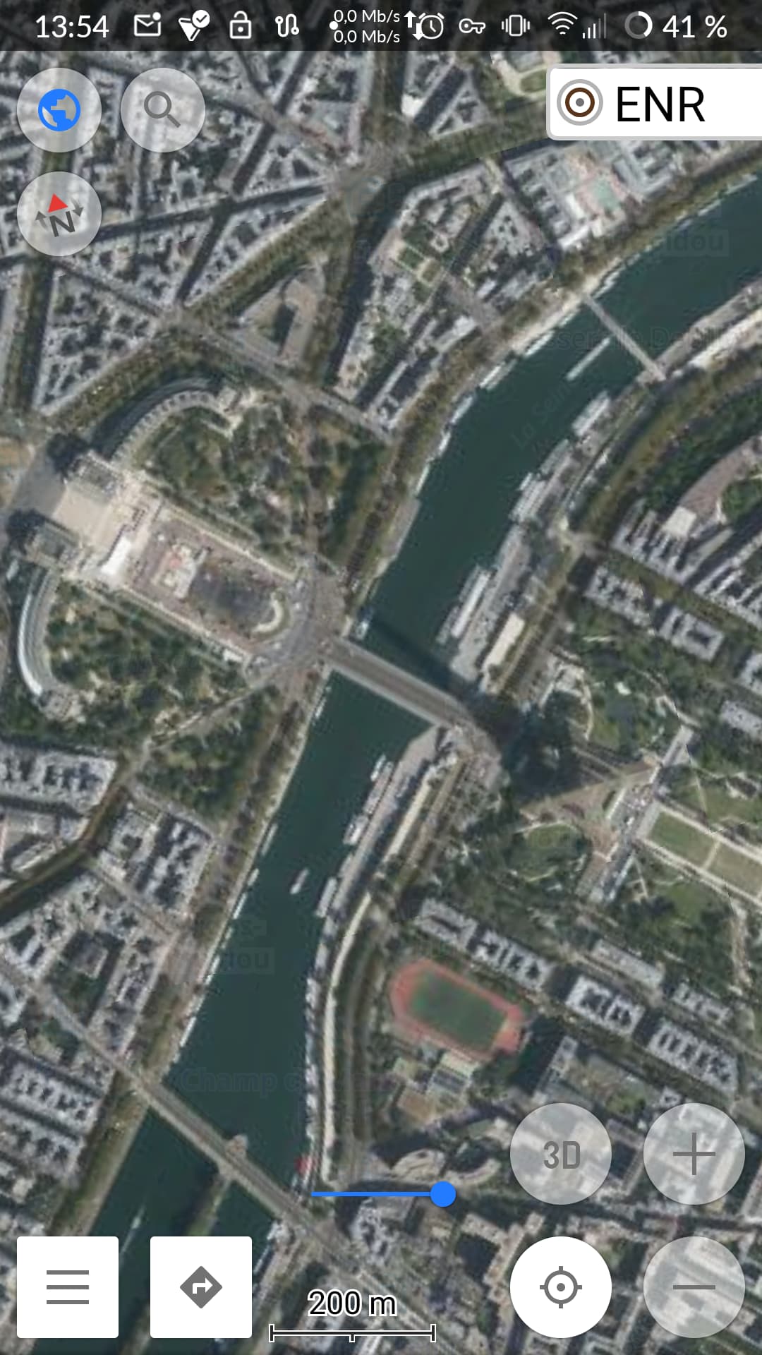
I can even say that sometimes satellite views in IGN (website or app) are more precise than G Maps
Yeah I think I had heard that before. I’m with you, better to go non-google.
That said, waze does work well on /e/ os, even with trackers blocked. I wonder how tied to google it is other that being owned by them. It definitely has far fewer trackers than google maps and is not as integrated in google services.
1 Like
For Waze, if it’s owned by Google, you can’t do anything to block data sent directly to Google (to confirm by an expert) because even on /e/OS, you need communication to Google services even if they are reduced at the minimum required (push notification for exemple)
1 Like
Did anyone try to add Google maps satellite view over Osmand~ ? I tried but unfotunatelly, you can add more satellite view of pre-existing choice only, you don’t have the possibility to add tiles manually unlike OsmAnd (so add Google satellite view).
Does anyone know if it’s a limitation or bug?
I’m wondering if it’s possible too to add IGN satellite view which has a very good quality.
I just tried this …
… and it works for me.
The only difference now for me is that in “Menu > Configure Map > Map Source > New:” the “New” is “Add manually…” in current OsmAnd.
2 Likes
At the end, it works fine after a second test.
Unfortunately, I didn’t find the way to delete the first map tile I created ans that doesn’t work. Any idea ?
With that, only trafic information is missing in OSMAND~.
Very nice GPS app
1 Like
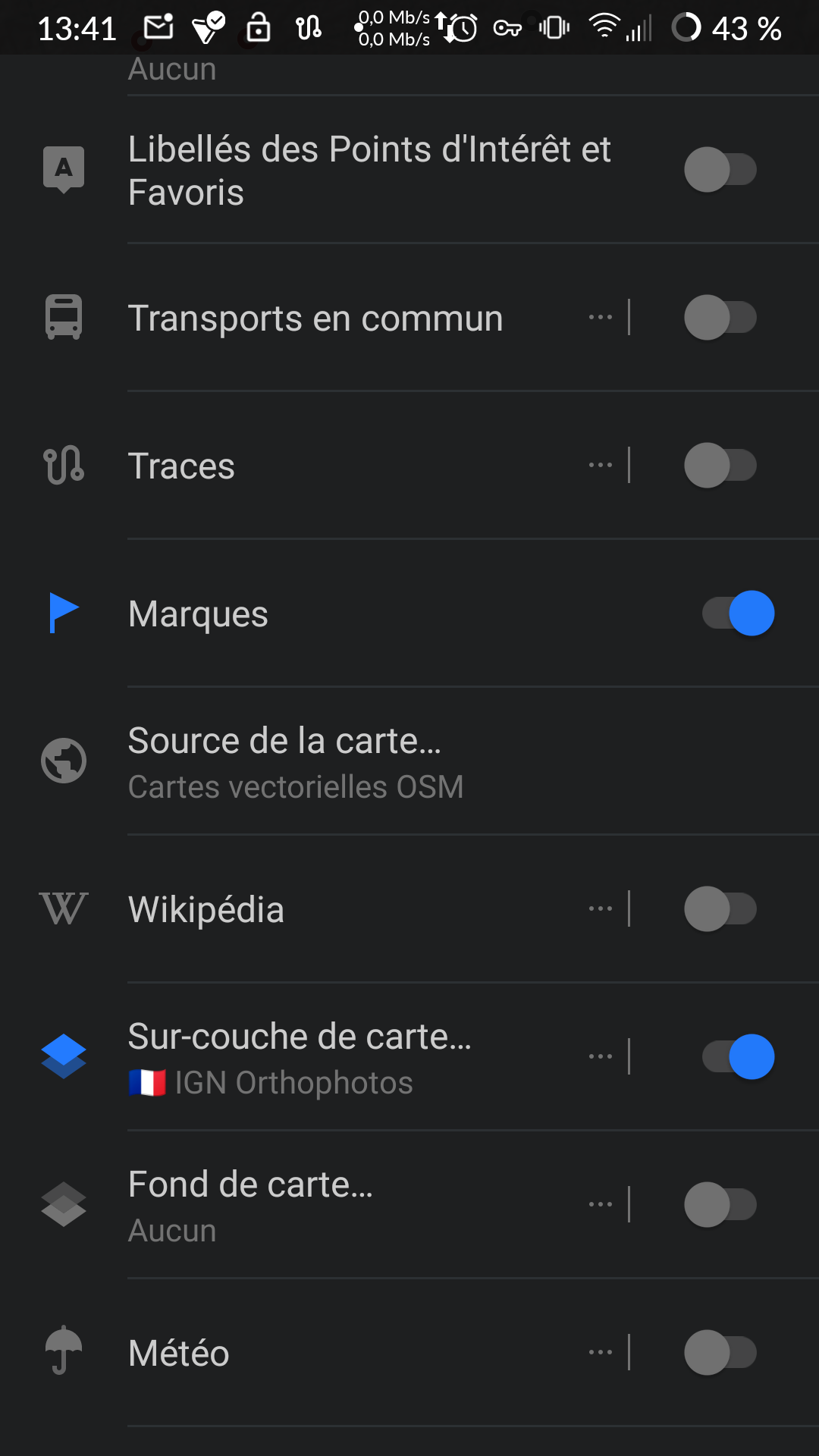
Menu - Maps & Resources - LOCAL - Map sources
There you can edit/remove the sources, or clear all saved tiles of a source.
1 Like
I followed a tchat on openstreetmap forum (Carte IGN Scan 25 sur OsmAnd+ Pro - #19 par Hades34 - osmand - Forum OSM France) and some people created a tile map from IGN data. For me it’s clearly better than Google one (precise map but heavier to load of course, privacy because nom Google stuff). Perhpas limited to France… To double check
The file is here in the repo: Online-Maps/FR at main · OsmAnd-Rendering/Online-Maps · GitHub if anyone is interested.
You download the file, open it with osm and everything works fine !!! Nothing to setup

1 Like
I find that Microsoft earth layer is mostly good enough for satellite image in Osmand Maps. But if someone was to use Google map overlay how would that affect their efforts to maintain privacy from Google Maps tracking them or even just in general keeping their phone Google free?
Thanks for your info btw.
As for keeping a phone Google free …
By using any Android OS, be it any vendor stock OS or any so-called custom ROM, most of the code actively running on your device was written by Google. An OS like /e/OS if you follow the trail back via LineageOS is still based on Google’s Android Open Source Project (AOSP).
I think “degoogling” the way it is used as a term right now is kind of a marketing term in lack of a better short term for what it is trying to name … limiting data harvesting and the network connections used for it as well as unbinding you from certain services. Making or keeping a phone Google free it is not.
As for the map overlay …
You are giving OsmAnd a URL template to directly fetch Google’s map tiles from Google’s server like a browser. So Google will see (if they bother to look) that a user got certain map tiles, I don’t know which info the user agent string given to the tile server includes in OsmAnd’s case.
It will not come as a surprise that if you want to maintain as much privacy as possible from Google, you should not use services offered by Google.
Using Microsoft’s services in the same manner as Google’s is okay?
So what I’m seeing is, google is inescapable, microsoft is pretty much equivalent to google. Resistance is futile. Oh well at least I don’t have google play services constantly running in the background
no @Peter1 , the resistance is the only way to build a better world in which we would be free and not spied every minutes by companies using you data to make money on your back
Yes, we have to keep in mind that Trackers are only the data that is sent from an app to third-parties.
Blocking all trackers does not mean at all that the app itself is not sending data to its main editor, which it is obviously doing at least as much as it is sending data to third party.
The app is free because it is using our data, sending data to third party is a way to increase revenue, but google earns money with its own user targeted advertisement service, so collecting our data through waze/chrome/android/googleAccount/gmail/gmaps themselves is already its main way of earning money.
This cannot be blocked as we cannot separate the network traffic, from legitimate to private data collection, that the app is sending to its own server, otherwise it would block the app functions. It would also not be fair to app editors: google is not hiding its business model, we are willingly using or not its services knowing that they will use our private information to finance the app development, servers and margin/profit.
1 Like
I was being a wee bit facetious about the resistance thing. So getting back to my original question. Im getting the impression using google for satellite view isn’t much better or worse than using MS ?
Hi @Peter1,
From quality usage perspective: it’s a personal point of view I think.
From data collection point of view: for me it’s the same but only Google and MS can really answer.
For information, I read somewhere that MS will join a kind of open source alliance in map to be able to have a competitive tool compare to Google Maps. Does it mean, better privacy, I can’t say
Better privacy? Probably not likely. Better transparency maybe at least.
In France, one could use “Cartes IGN” (fr.ign.geoportail), founded with our taxes and tracker-free ![]()
No navigation, but route tracing/planing is included.
1 Like