Hi All,
I run 0.18 on my FP3+ and recognized that I can’t share my position via signal. Can you check if you have the same problem? If so, it would make sense to open a bug… So, let me know please if you can share your location with signal or not.
I can think of multiple ways to do that. Please try to describe the method, that you want to use for sharing your position, as precisely as possible, so that your issue can be identified.
Hi Markus,
I use the ootb function of Signal. Steps to reproduce:
Open a chat
Press “+” on the right hand side of the text window
select “location”
Wait until your location is found
confirm
Now: expected behavior would be to see an arrow that sends your location but this arrow does not appear. Instead the “+” is still there. The position on the map is displayed within the chat but there is no way to share this position since the the arrow to send the position is missing. Entering text will cause the arrow the appear but wont share the location.
Thank you for your interest and I hope this helps.
Regards
Aleks
FWIW, a similar issue appears on some apps, like in Paris the one to guide you through bus and metro, labelled ‘Bonjour RATP’ : it works perfectly well, save the specific function “guide me from where I am”, which just doesn"t manage to detect one’s location.
This, even though OSMAnd is converged, and, for instance, the competing application CityMapper does find the location…
So, visibly, there are ways to solve the issue (CityMapper does it) but there are other guys that, well, probably use too much of those Google things that we avoid here…
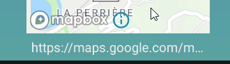
[edit] that may also be related to the fact Signal uses Google maps to show you on the map, rather than Openstreetmap : maybe, the google map demands more relation go google than /e/ allows…
"This will be tagged with help wanted. So the people who believe in free Software can contribute.
It can make use of other maps…"
The last sentence may indicate that the use of Google Maps could cause the issue. As others in this forum recommended openstreetmap already, we may want to launch an enhancement request at Signal to use openstreetmaps parallel to Google Maps for MicroG enviornments. What I am not sure about is: does it make sense to open a feature request at Signal to add openstreetmaps or should MicroG emulate the call to Google Maps with openstreetmap to support multiple use-cases? I am afraid I do lack the technical knowledge to judge on what makes more sense… Does someone has a better understanding of this? I think we should not have open requests at Signal & MicroG. It should be one request only to save resources but what makes more sense?
I think it’s quite clear that Signal team won’t add support, but aren’t against if someone else does. That’s why they labeled it as “help wanted” IMHO.
Unfortunately I’m not programmer either, hopefully someone with know-how does help and offers solution to that.
Yes you are right, I missed that point. They asked for help. Maybe the MicroG Team is the right place to ask for this help since we don’t have the skills to do it our own. I can ask them if they are ok with this effort unless someone has a better idea?
Got feedback from the MicroG team: It looks like the issue is caused by a function called >snapshot< which is not yet implemented in MicroG. The function is using the Maps API to send a snapshot of a map as picture. I hope this description translates well.
An >Issue< was created to track this request. The effort associated with this shouldn’t be too much according to the MicroG team.
However they are busy now and can’t work on this. So, can anyone from this thread work on this with the information above? Does anyone here have an idea who to ask for help outside of this thread?
Hi @Aleks4e interesting research. My first reaction was that the snapshot feature would be unnecessary for me and as for their request for help if you were to add your research to their bug, drop snapshot might be a way for them to clear their bug.